
Month: September 2025

Reinebringen ENG

Reinebringen

Best hike in Lofoten?

QUI INDICE

Reinebringen is one of the most iconic and famous mountains in the Lofoten Islands, looming over the village of Reine.

Despite its modest altitude of around 484 metres, it delivers exceptional, sheer-drop panoramas.

Its relatively simple access, proximity to Reine, and viral fame have made it extremely popular, crowded with tourists hauling themselves up and down all day (and night…).

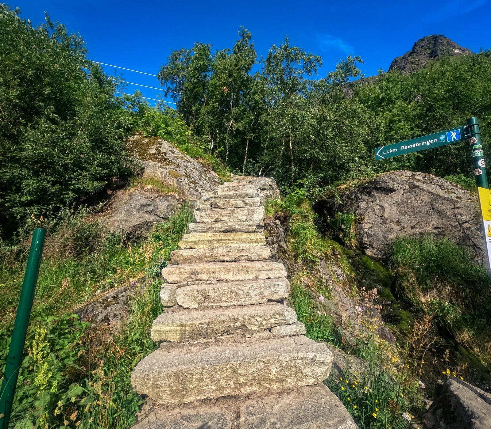
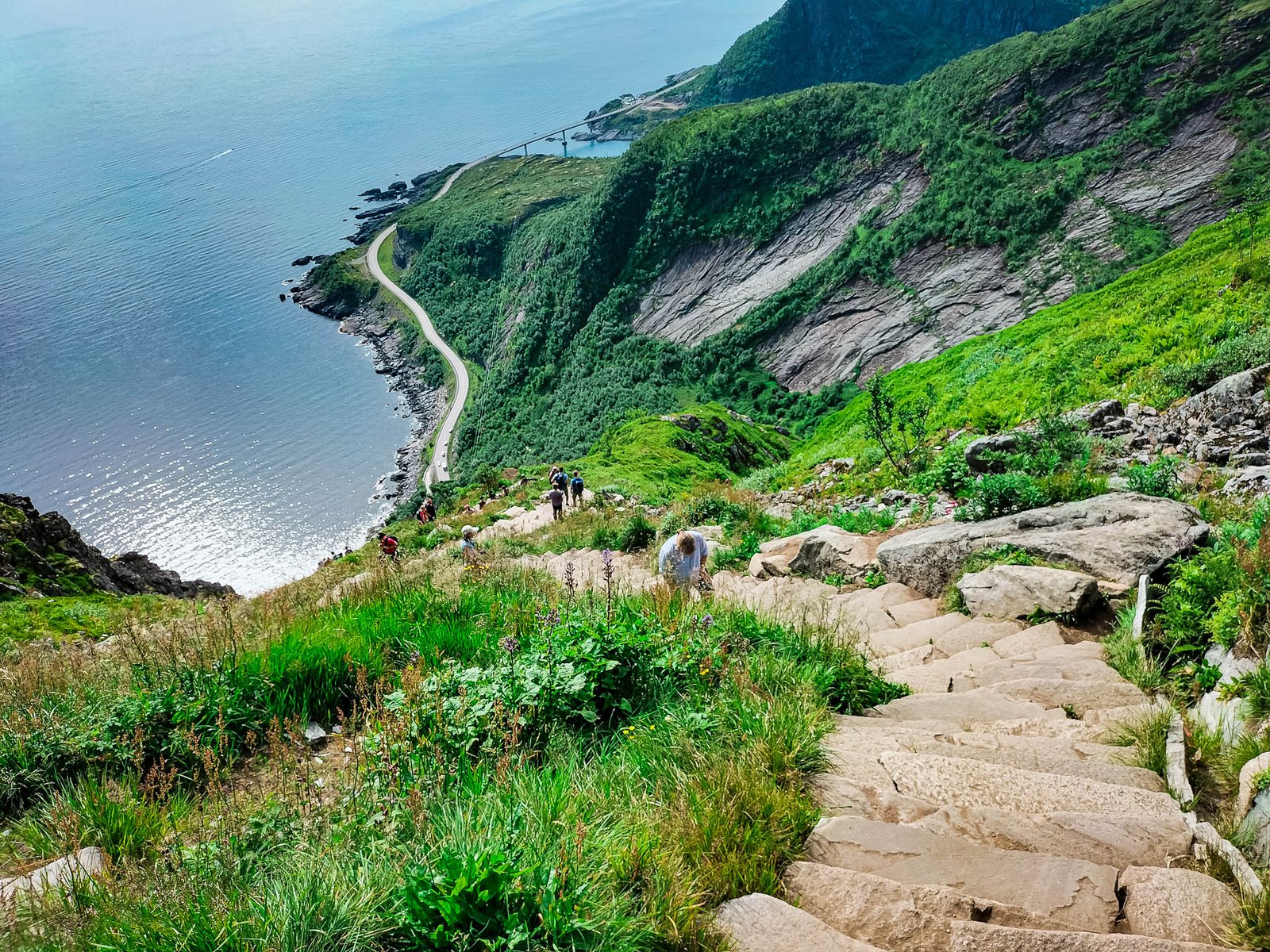
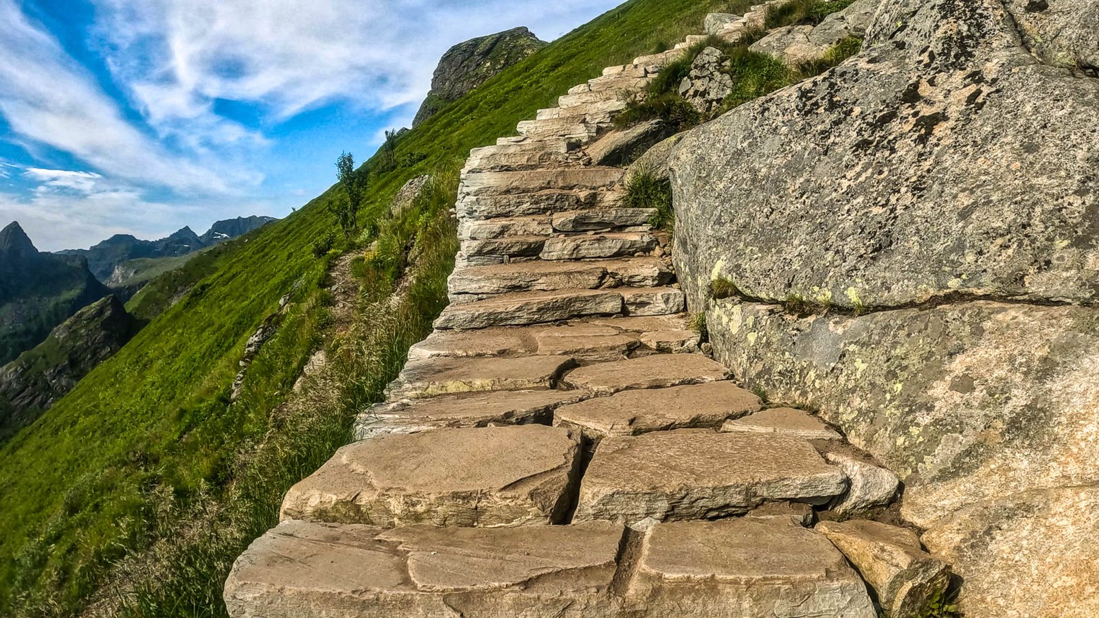
The climb to the summit is defined by a steep stone staircase, built by a team of Nepalese Sherpas and composed of approximately 1,978 steps.

But the question remains: is the fame deserved or not?


Location Lofoten Islands, Moskenesøya, near Reine, Norway
Difficulty Moderate / Demanding (due to steepness and stairs)
Avg Time 1.5 – 3h Return
Ascent 448 m
Distance 2 km Return
Elevation 484 m
Trail Type Marked trail, 1,978 stone Sherpa steps, final section on natural ridge
Start Point Location
How to get there From Reine: Walk along the pedestrian path by the sea towards Å, until you reach the Sherpa steps.
Water Not available along the trail.
Best Season May – September
Facilities None. Camping is NOT allowed on Reinebringen.


Open on Google Maps


On some devices, you may see a Google Maps error message. Simply tap “Try Again” and the map will load normally.


QUI

ALTRO

VISIBILE

SOLO

DA

PC

E

VA

IN

FONDO

SU

PHONE

TIPO MIE INFO E LINKS

QUI BANNER CON ALTRO

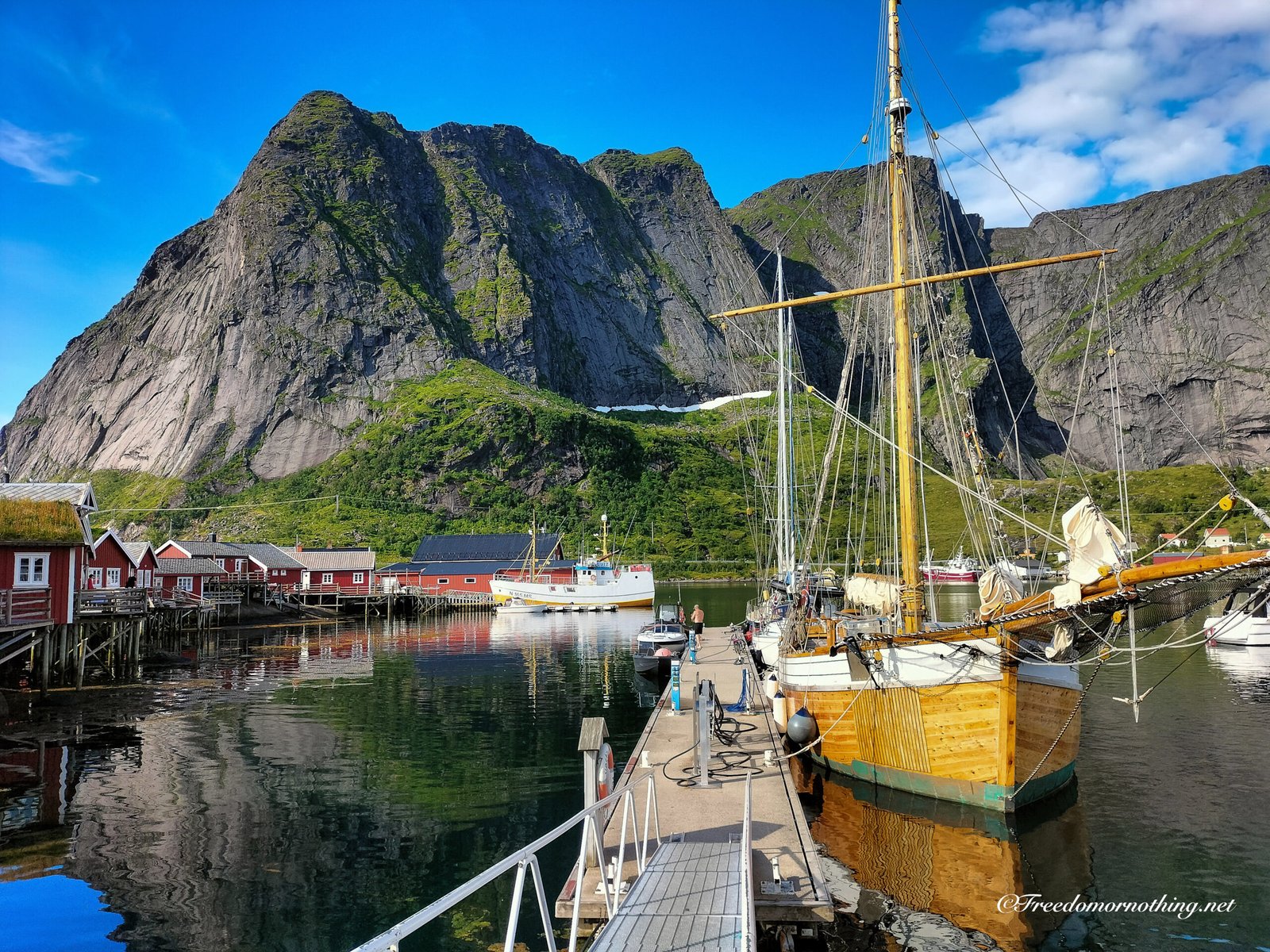
Reinebringen view from Reine…


LET’S START

I confess, the reason that dragged me to Lofoten the first time was one of the many videos showing the eye-popping view from the summit of Reinebringen.
I go mad for steep trails and vertiginous views, and this seemed to be the definitive version of what I was hunting for.


The knowledge I have today of this sensational archipelago was learned “in the field,” but back then, I knew absolutely nothing. I left improvising everything, driven purely by this impulse of wonder.

qui banner solo telefoni


Starting from the “Reinebringen” bus stop, you follow a pedestrian path for about 1 km, at the end of which the famous staircase kicks off.

The trail is evident and well-marked, even if the elevation gain can be intense for some, with gradients up to 45%. However, it is possible to stop at the stone bench areas scattered along the ascent to catch your breath and soak in the view.
The route can get crowded, especially in the middle of the day. I remember during my first ascent feeling a bit annoyed by the constant crossing of paths with people coming down and going up.


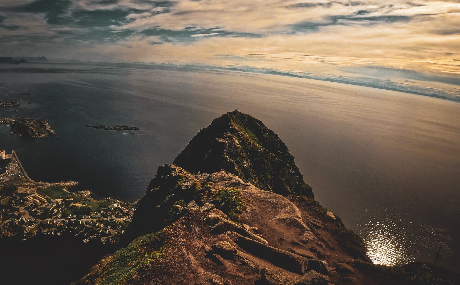
The final stretch before the summit is not “stepped”: here the trail turns into a natural path with no protective barriers, so you need to pay attention, especially in high winds or adverse weather.
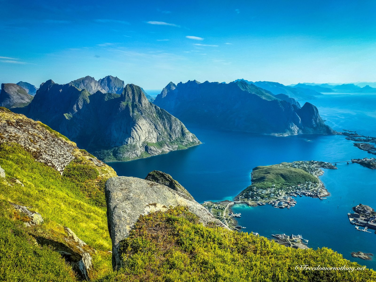
At the top, the height and dominant position gift you one of the most famous and photographed views in Lofoten.


The Best Hike in all of Lofoten?

The impact of the panoramas along the climb and on the summit hits hard and pumps adrenaline, yet I remember feeling like I wasn’t totally satisfied. I didn’t know yet that in the following days I would stumble upon other hikes that would even surpass my sky-high expectations
…and for those like me who don’t love places crowded with tourists in the grip of “Selfie Rapture,” it’s hard to enjoy this place to the fullest.

Answering the initial question, I believe the main role of Reinebringen is to bring people to Lofoten, funnelling the vast majority of tourists into a place where they can “easily” enjoy the beauty of the archipelago. Not all of it, of course—there is plenty else to see… But then the “Natural Selection” of preferences, attitudes, and conditions separates the routes of those who adventure towards hidden gems off the beaten track and those who prefer the iconic spots.


Hell, I’m not saying it isn’t worth climbing.—quite the opposite!
But there is much more…

Serious Stuff

  • Avoid hiking the trail in ice or snow conditions, when the ascent becomes extremely dangerous.
  • Bring sufficient water, as there are no refill points along the route.
  • Camping on the mountain is not permitted, for environmental protection and local regulations.
  • Respect nature, pack out waste, and always follow the principles of “Leave No Trace.”

If you want to discover the TRUE best hikes of Lofoten, you will find some here:

hhh

Restaurants

  • Maritim Hotel

    Auckland

  • Countryside Inn Motel

    Matamata

  • The Ocean Hotel

    Stewart Island

  • Novotel Hotel

    Hamilton

  • Forest Campsite

    Dunedin

Related Posts

Continue reading

Earnslaw Burn Track ENG

Earnslaw Burn Track

Between Wilderness and Timeless Views


Earnslaw Burn is the exact answer to the question, “Which place would you revisit in New Zealand if you had just one trip left in the chamber?”

This is, without a doubt, one of the most incredible, remote, and pristine places that struck my vision like lightning during my travels in the land of the Kiwis.

This isn’t a simple or quick hike. Unlike other trails, this one only starts to make sense towards the bitter end—you have to earn it. But what you find at the finish line makes you immediately forget the “price” you paid to get there.


Where
Glenorchy Area, Otago, South Island – NZ


Difficulty
Challenging


Average Times
6/8 hours one way (4/6 hours just for the bush section)


Total Ascent
1250m return


ircle cx=”3″ cy=”12″ r=”2″ fill=”#7daedc”>ircle cx=”21″ cy=”12″ r=”2″ fill=”#7daedc”>
Distance
13.5 km total (8.8 km in the bush)


Max Elevation
999 m a.s.l. (max elevation near the glacier)


ircle cx=”12″ cy=”9″ r=”2.6″ fill=”#fff”>
Start Point
Earnslaw Burn Track Parking off Lovers Leap Road


ircle cx=”7″ cy=”18″ r=”2″ fill=”#666″>ircle cx=”17″ cy=”18″ r=”2″ fill=”#666″>
How to get there
From Queenstown, drive about 45 minutes on sealed road to Glenorchy. From Glenorchy, head towards Paradise and shortly after Diamond Lake, turn right onto Lovers Leap Road (gravel road). Drive for about 1.5 km and you’ll find the parking for Earnslaw Burn Track. The trail kicks off from here.


Water
Available. Sourced from the Earnslaw Burn river and from streams and waterfalls crossing the track. Filtering or boiling is strongly recommended.


Services
None. Camping is permitted in the area adjacent to the river just as you break the treeline, before the upper valley.


Recommended Season
December – March

  • Info & Highlights

  • Dove:

    Area di Glenorchy, Otago, Isola del sud – NZ

  • Difficoltà:

    Challenging

  • TEMPI MEDI:

    6/8 ore solo andata (4/6 ore solo bosco)

  • Punto di partenza

  • COME ARRIVARE:

    Da Queenstown, guida circa 45 minuti su strada asfaltata fino a Glenorchy. Da Glenorchy, prosegui in direzione Paradise e poco dopo Diamond Lake svolta a destra su Lovers Leap Road, strada sterrata. Prosegui per circa 1,5 km e troverai il parcheggio per Earnslaw Burn Track. Da qui parte il sentiero.

  • ACQUA:

    Disponibile. Reperibile dal fiume Earnslaw Burn e da torrenti e cascate che attraversano il sentiero. Filtro o bollitura fortemente consigliati.

  • SERVIZI:

    No, camping consentito nell’area adiacente al fiume appena usciti dalla linea degli alberi prima dell’alta valle.

  • Periodo consigliato:

    Dicembre – Marzo

  • Dislivello positivo totale:

    1250m 

  • DISTANZA: 13,5 km totali (8,8 km bosco)

    13,5 km totali (8,8 km bosco) solo andata


LET’S START

After ditching the car in the small parking lot, you’ll spot the trail starting from a rural gate that closes off the paddock near a wooden sign. Use the stile next to the gate to hop over without disturbing the livestock, and push on, following the path that gently climbs through the fields until you hit the tree line.

From here, the trail gets technical and spills into several kilometers of ups and downs inside the real forest—”wild” in the rawest sense: terrain that is never trivial, roots, mud, fallen logs, streams, and a track that vanishes every now and then between the orange markers on the trees. You’ll understand immediately that this isn’t a “walkway” for selfie-tourists, but a rough, living track.

You will genuinely feel on the edge, far from everything.

In short: no comfort, no giant billboards, no fast lane—just you, a dirty trail (as you will be by the end of the day), and the feeling of truly setting off on an “old school” adventure.

You need to pay attention; it’s often easy to lose the track, especially after rainy days that can trigger small slips and alter the lay of the land. There are some steep sections on scree/gravel that you need to tackle with caution so you don’t slide out.


Note: The trail, within the bush area, winds mainly through public conservation land (DOC). Camping is only permitted near the treeline, just as you exit the forest and close to the river (approx. 10 m), near the natural rocky bivvy, before entering the high valley towards the glacier, which sits on private land (Earnslaw Station). As of 2025, there are signs indicating exactly where you can camp.

You won’t find “red carpet” trails like on the Great Walks, but with a minimum of experience and focus, it’s not that terrible.

After about 9 km that seem to never end, you glimpse the light piercing the last dense ranks of trees, reigniting your spirit and delivering a solid lash of dopamine. The moment you step out, you’ll find yourself at the mouth of the valley with the Earnslaw Burn river flowing on your left. You can camp here.

You can push on directly toward the slopes of Mount Earnslaw/Pikirakatahi and pitch your tent on the return, or set it up immediately, rest a bit, and then head with more calm toward the real reason you are here.


I regretted not having my tent with me that day; in fact, I had minimal gear, and I had started mid-afternoon, returning in the dark with a headlamp late in the evening.

For those who know me, I usually pull rather wild stunts with timing and organization that are dubious at best, and in conditions that are often insane… I strongly advise against doing the same, because often it isn’t the best way to appreciate what you’re doing, it’s simply… my way.

Back to us… Unless you are a seasoned trail runner, staying overnight or starting very early are the best ways to enjoy this magical place.

It is possible to do it all in one day, but the effort is truly significant and the timing very tight, especially if you’re hauling heavy gear.

By staying overnight, you’ll have the chance to spend several hours at the top, savouring all the different colours that wash over the glacier, valleys, and waterfalls from sunrise to sunset, and (why not) living through one of the most indelible starry nights of your life.

The last steps

From here on, the route continues mostly flat with gentle undulations on soft, lush ground that, once you round the corner, opens up onto the high valley in front of you and…

“Welcome to Earnslaw Burn”!

I have never found any photo of this place, least of all mine, capable of truly showing the sensation of vastness, purity, and imposing scale of this valley, where the glacier lights up in the sun and an avalanche of waterfalls, large and small, give life to the meandering river that accompanies you to the skirts of the mountain.

It is possible to reach this hidden pearl by hiking the trail I described, or via some companies that offer “heels and ties” experiences rather than “boots and sweat,” landing with helicopters in the valley. Fortunately, the day I decided to hike it, no helicopter changed the atmosphere of that place. In fact, I believe there were no more than 7 of us in the entire valley from 5 PM onwards.

The most significant encounter I had was a long exchange of gazes with a deer, far from frightened by my presence.

Magnificent.

The image best preserved in my memories of this experience is the last kilometers in the high valley when, at every step, my jaw dropped, leaving me mouth wide open like a fish, stunned by amazement, asking myself, “Where the f*** am I?”


Safety and Tips

I hiked this trail on a hot, clear day in late February, and I recommend doing it in clear sky conditions, checking for any updates on track status on the official DOC website. The avalanche risk, especially in the off-season, is significant. It is important to carry food, warm layers, tell someone your intentions, and be prepared to find yourself alone, far from any kind of comfort.

Earnslaw Burn is a marvelous and uncorrupted valley that must be preserved and kept that way. You need to organize yourself to pack out any waste and, as always, LEAVE NO TRACE.

If you have questions or want to exchange a few words, or if memories jumped to your mind reading this story, Drop a comment below or DM me on Instagram.

Articoli correlati

NEW ZEALAND

  • Wild Camping regole e consigli in NZ

    Auckland

  • asdfghjk

    Matamata

  • a

    Stewart Island

  • e

    Hamilton

  • BOOTS OR SHOES?

    Dunedin

GEAR

  • ASDASDAS

    Wellington

  • Cannibal Burgers

    Milford Sound

  • Luigi’s SFASFASF

    ASF

  • ASF

    Te Anau

  • asasgdsd

    Tauranga

Similar Trips

  • Hiking in New Zealand

    Lorem ipsum dolor sit amet, erat mi sit augue etiam placerat enim, egestas metus, suscipit vel magna, aliquam neque erat pellentesque. Ligula elementum dignissim semper mi gravida

    Read the Full Story…

  • Otago Rail Trail bike tour

    Lorem ipsum dolor sit amet, erat mi sit augue etiam placerat enim, egestas metus, suscipit vel magna, aliquam neque erat pellentesque. Ligula elementum dignissim semper mi gravida

    Read the Full Story…

Continue reading